 Urbanism
Environment
Design
Environment
Design
Chapelgarth Latest Masterplan: Tell us what you think!
Following our exhibition at the Box Youth Project on Saturday 30th January 2016, the exhibition material and details of our latest masterplan for Chapelgarth are now available to view online.
- Click here to view the exhibition boards displayed at the Box Youth Project (please note the files are large so download may take a while.)
- View the handout information from the event here which includes the technical notes and masterplan handout.
- Once you have had a look through, we would really appreciate it, if you could fill out an online questionnaire to provide us with your thoughts and feedback on the masterplan, survey link here. Please note the survey will stay open until 13th February.
THE PROPOSALS
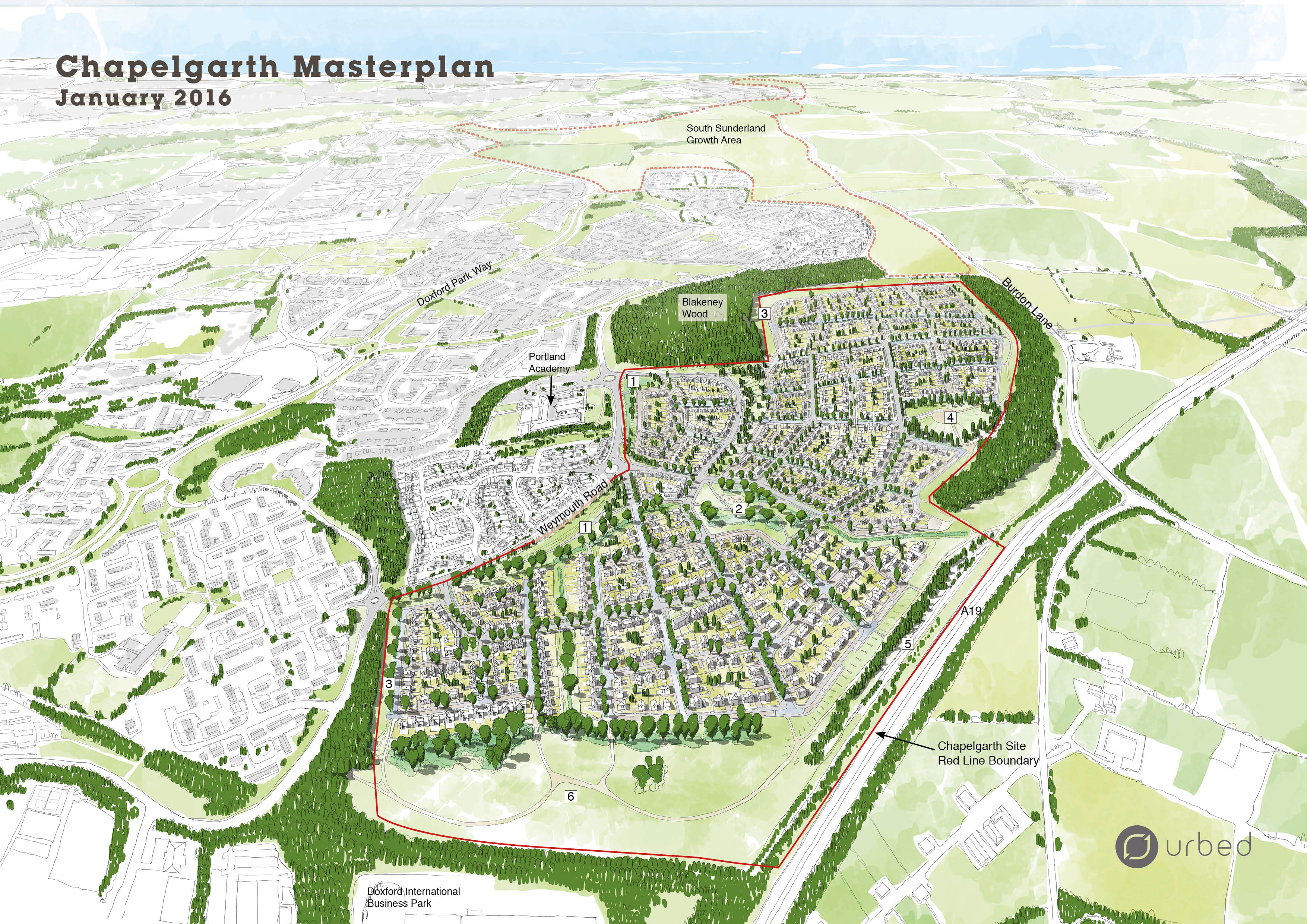
The 3D aerial sketch below is the current masterplan for the site:

The Landscape Strategy
Numbers in the table below relate to those on the 3D aerial above. The designs for the landscape will be detailed in the Design Code, which will fixed as part of the outline planning application, ensuring the development is built out as intended.
The box below details the different elements of the Landscape Strategy:
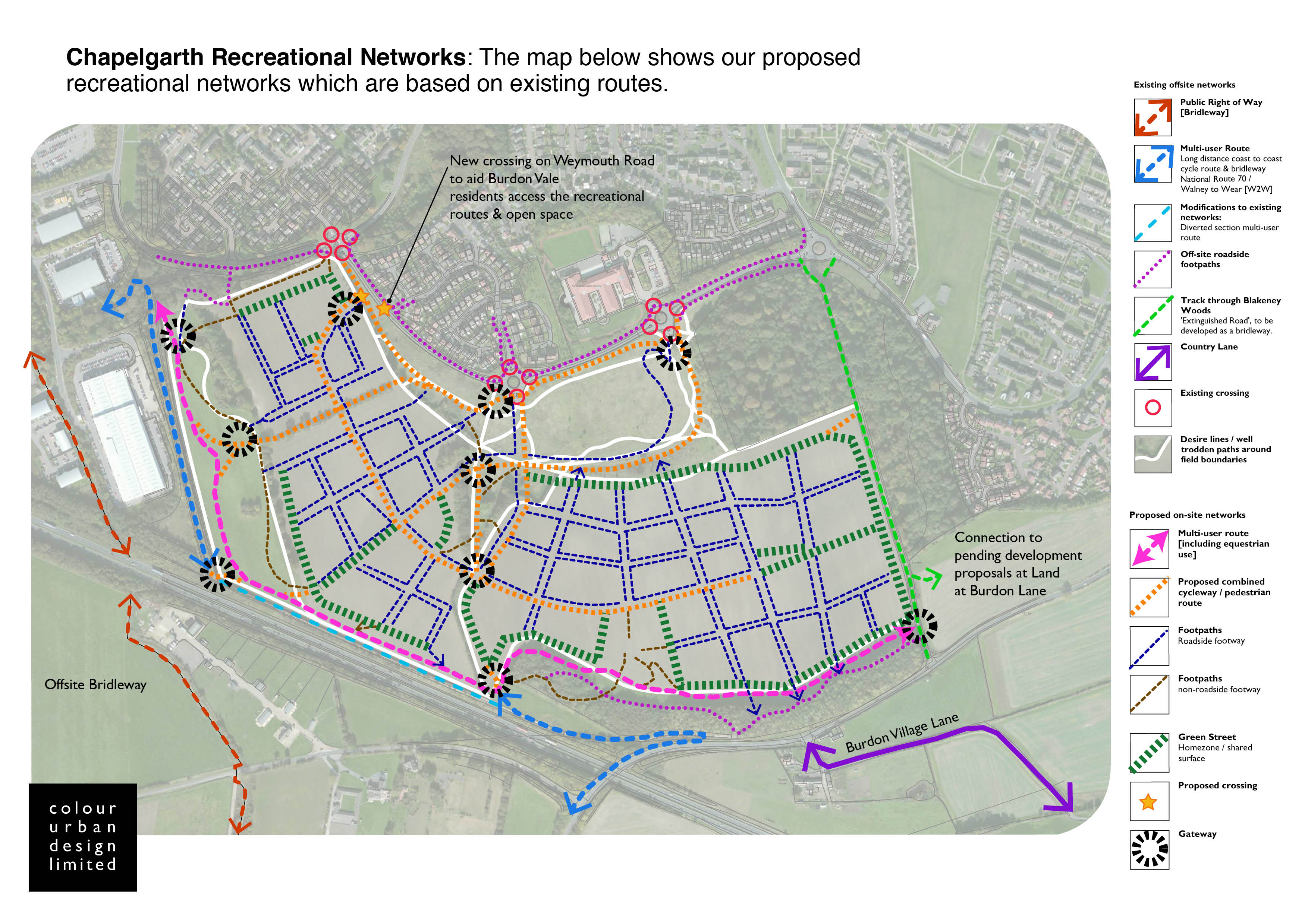
- Recreational Networks: The map below shows our proposed recreational networks which are based on existing routes:
- [1] Weymouth Road: We have increased the green buffer between Weymouth Road and the new development in line with local resident’s comments. Drainage ponds will also be provided here as part of the drainage strategy. These will look like grassed basins and will only fill with water during extreme storm events. This means that most of the time they can be enjoyed as parkland.
- [2] Central Park: At the heart of the scheme is a newly created neighbourhood park, which is defined by existing mature trees and hedgerows. A network of footpaths will permeate the park for recreational use. A play space will be provided in this area to attract young children and families.
- [3] Allotments: Two areas have been allocated for the provision of community allotments.
- [4] Panoramic Park: The panoramic park will take advantage of the elevated setting of the site and will provide a public open space for all to enjoy the views of the city and the sea. The earth modelling of the raised park will create a land sculpture and provide a focus within the development and a tranquil spot for the community. There are opportunities to provide play facilities for all ages within the park with associated seating.
-
[5] Magnesian Way: A generous green edge has been provided along the southern edge of the site. The proposals include the construction of a raised earth bund and green barrier to deflect noise from the A19. A multi-user route for equestrian, cycle and general foot traffic is proposed to the top of the bund to enhance views out to the sea and across Sunderland City. We are proposing to direct the W2W National cycle route onto our multi-user route, in order to move it away from the A19, and enhance users experience of it.
-
[6] Natural Greenspace: The proposals aim to maintain as much existing open space as possible. This area will be retained and enhanced to be enjoyed as open greenspace and will be allocated in the proposal as a ‘Sustainable Alternative Natural Greenspace’ (SANG). SANGs provide alternative recreational spaces which can help reduce visitor pressure on other areas along the coast which are home to protected bird species. We have allocated 13.5 ha of SANG on this masterplan and are proposing to add new footpaths to make it more accessible and link it to the existing cycle routes.
-
Play Spaces: Play spaces have been provided throughout the new development in the form of doorstep parks overlooked by dwellings, larger equipped play areas within the Central and Panoramic Parks and natural informal play installations alongside the green networks.
-
Pocket Parks: Small local parks have been proposed within clusters of housing to provide doorstep play and community seating areas within 3-5mins walk from homes throughout the development.
Key Information
New Housing
- The scheme can accommodate up to 750 new homes, providing a mix of types and tenures. All 3, 4 and 5 bed homes will have a minimum of 2 parking spaces.
- The density responds to the landscape design: higher density housing is situated towards the centre of the scheme to create a sense of place, like a traditional village centre, with lower density housing around the edges, which reflect the green and wooded areas around the site edge.
- We are proposing to provide family homes across the site, with a minimum of 20% of new homes to have 5 or more bedrooms. An indicative mix of housing across the whole scheme is detailed below:
- 5% to be 2 bedroom houses;
- 20% to be 5+ bedroom houses and;
- 75% to be 3 or 4 bedroom houses
Access
Vehicular access into the site will be off three points on Weymouth Road. A primary route runs through the entire development and has been designed to accommodate a bus service. The residential street network will then feed off this route.
Drainage
- A detailed drainage strategy, submitted as part of the planning application, will manage water movement and storage around the site. This strategy responds to the topography of the site and proposes:
- Swales along streets to hold water. Swales are shallow vegetated channels designed to slow surface water run off.
- Drainage ponds - these will retain water in the event of a severe and prolonged storm, and will discharge it slowly into the water sewer, so as not to inundate it.
- Trees will be planted to capture surface water run off along new streets.
Landscape and Ecology
- We are providing 13.5 ha of natural greenspace which is the equivalent in area to 18.2 Football Association senior sized pitches.
- On top of this we are also providing parks, allotments, play spaces, pocket parks and new tree planting throughout the scheme.
- We are aware of the importance of the woodland and hedgerows around the site and we have incorporated into the landscape strategy the provision of green buffers. These indicate areas where no housing development can take place and include a minimum 25m buffer around woodland areas such as Blakeney Woods and a minimum 10m buffer around sensitive hedgerows.
- Our proposed public routes are based on how people currently use the site. We aim to provide a circular route through the natural greenspace, which also connects into the W2W cycle route to the south of the scheme. Pathways will also be provided within and around the new parks.
Next Steps
Following the exhibition, we will collate responses and circulate these to the design team, before any final amendments are made to the masterplan.
The planning application is due to be submitted for the scheme at the end of February 2016, after which members of the public will be able to comment on the application through the planning process.